Geoarchaeology
Geoarchaeological investigations of the environs of the Neolithic Site of Avgi
Geoarchaeological investigation at the site and the environs of Neolithic Avgi indicates that geomorphic agents of hillslope erosion and valley alluviation have affected the settlement and the wider landscape.
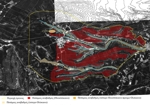
 Intensive field exploration on the ground of an area of ca. 20 klm2 produced a detailed 1:5,000 scale geomorphological map (Figure 1). Geomorphological mapping classified the landscape according to the dominant process that formed the present surface. The end product delineates areas where surface visibility and site integrity may be compromised by soil erosion, or alluvial and colluvial sedimentation. Limited stratigraphic investigation, using a JCB, verified and enriched our knowledge of the alluvial history of the area.
During the late Quaternary, the two stream that presently flow north and south of the neolithic settlement have deposited alluvial sediments that presently form three discrete river terraces.
The oldest terrace (shown in red in Figure 1; also see Figure 2: No 1) forms a wide, gently undulating surface that dominates the study area. The neolithic site of Avgi was founded on this terrace. The oldest geomorphic surface of the study area has been seriously affected by erosion. The soil formed on alluvial sediments is preserved truncated to the B and occasionally the C horizon. It appears that the neolithic settlers of Avgi inhabited an already eroded landscape. Furthermore, prehistoric, but also historical archaeological sites, situated on this terrace are expected to be severely truncated. It is also conceivable that ephemeral or perhaps early archaeological sites may have suffered partial and/or total destruction.
The second river terrace (shown in orange in Figure 1; see also Figure 2: No 2) was most likely formed during the late Pleistocene-early Holocene. It is very poorly exposed on the modern surface and it is also eroded. Stratigraphic investigation immediately east of the neolithic site of Avgi, however, showed that during occupation of Avgi, the late Pleistocene-early Holocene river terrace (then possibly active floodplain) was extended in a wider area, was visible on the surface and the soil formed on top of alluvial deposits was available for cultivation and/or other use. Later stream adjustments, have eroded this former floodplain, while some parts of the terrace are preserved buried under later alluvial and colluvial deposits.
The younger river terrace (shown in yellow in Figure 1; see also Figure 2: No 3) presently occupies a relatively large area. According to a radiocarbon date, alluvial sediments that form this terrace were deposited some time after 670-830 AD.
According to surface and subsurface observations, preservation of unknown archaeological sites buried under alluvial sediments and intercalated soils, comprising the two younger river terraces, seems rather unlikely.
A wide area west and north of the Neolithic site of Avgi has suffered severe erosion during the past (Figures 3 and 4). The ancient A soil horizon is nowhere preserved on the surface. Therefore, archaeological sites founded on these particular areas of the landscape must have been affected by postoccupational erosion.
Geoarcheological investigation at the site of Avgi itself is in progress. Preliminary observations indicate that lateral migration and stream incision eroded parts of the site. Moreover, the neolithic deposits have suffered post depositional hillslope erosion, exacerbated by arable cultivation (ancient and modern). Colluvial deposits originated from the settlement have been identified in stratigraphic sections south and east of the site. Completion of geoarchaeological investigation will clarify the role of different geomorphic agents in preservation and/or destruction of the archaeological deposits of the neolithic site of Avgi.


